
The U.K.’s Celtic lands of Croyde and Woolacombe area joy for any traveller. Story by Lesley Choyce.
After the publication of my 2022 book Around England With A Dog, I began to falsely believe that I really knew England – geographically at least, and even somewhat intimately from our thousands of kilometres of travel around the kingdom by the sea. Along with my wife Linda and our dog Kelty, I had inspected Celtic corners hither and yon and knew my way from Eastbourne to Penzance, Grimsby to Scarborough, or any other stretch of English coast you could name.
Alas, notions of literary grandeur quickly faded when my dog/ travel book was soon toppled from the Amazon bestseller list (Travels with Pets category) by Nala’s World (about a cat), Life with Pigeons (self-explanatory) and even East Coast Trees and Shrubs (since when was a shrub a pet?). A close study of my dog-eared 2008 copy of Collins Superscale Britain with its 240 pages of maps the size of dining room tablecloths also brought me down a notch or two when I had to admit to the map and myself that I had become only mildly acquainted with coastal Britain and certainly not the heartland heaths beyond the scent of salt air.
So, the sad truth is, I won’t really get to see all that much of England before I die, but I will have done my best. And I believe that was at least part of my motivation to prompt Linda and I to venture across the pond from Nova Scotia yet again and experience whatever there was to explore on the Southwest Coastal Path from Croyde Bay to Woolacombe.
I have learned my lesson about late night driving after a daytime flight from Halifax to Heathrow and ending up in crappy M highway hotels in Reading, so now we regularly bed down at the Aerotel right in Heathrow. The room is the size of my walk-in closet at home and there are no windows, but we arise the next morning rested and ready to ride without emotional baggage.
The reward was a fine lunch at a little take-out food stand high above Croyde Bay called the Beach Café. Even though the cold winds were whipping in from the Atlantic, it felt like a picnic to sit on the hood of our rented car and sip dark roast coffee and a delicious gourmet BLT served up by a couple of dreadlocked young entrepreneurs. They even brought a silver tray of food to our car like in the old California days.
We were on our way to hike Baggy Point but first wanted to check out the famous surfing beach at Croyde Bay. Croyde is supposedly a Celtic name for the Viking scoundrel Crydda who made the usual pillaging holiday here a long, long time ago. But it may also have derived from an old Cornish word meaning “curd.” And I am happy to leave the solving of this riddle to linguists bivouacked in old austere English universities.
Nonetheless, gazing out on the sheltered cove of Croyde Bay where some wannabe surfers in a surf lesson were splashing about in the small clean waves, I couldn’t help but envision a Viking ship charging ashore here on a fierce ocean swell with a lustful crew ready to boldly claim this corner of the seafaring world for their own.
 The town of Croyde gets a nod in the famous Domesday Book of 1086, noting that the place had 100 sheep and 11 cattle and certainly there must have been at least a handful of humans around to mind the beasts. Today the population is 614 although that must swell to at least double that in the summer.
According to stayindevon.co.uk, “The unspoilt charm of Croyde is perhaps a surprise considering its fame as a top surfing resort. The village has a certain old-world feel, where thatched colour-washed cottages and traditional village stores rub sandy shoulders with hip surf shops, restaurants and a great ice cream parlour.”
I admit that is a funny mix of qualities, sandy shoulders notwithstanding, but it was a great place to tromp through to get to the less hip, less glamourous Baggy Point trail.
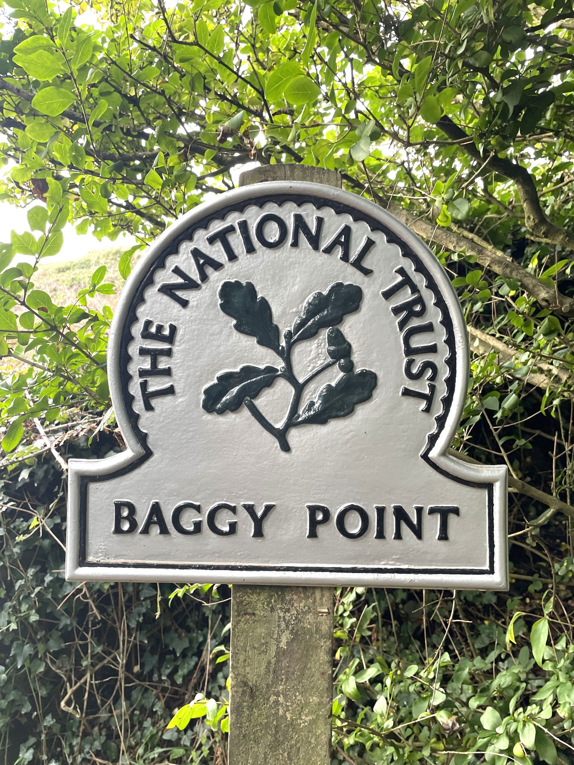
Why Baggy Point? you might logically ask since we were bypassing so many of the more famous tourist locales. The answer of course is that it looked like a most interesting headland, a phallic peninsula jutting out into the sea where almost no one lived. Once out of town, we found the trail rugged, steep, and much to our liking.
Constance and Florence Hyde generously donated Baggy Point to the National Trust in 1939 and the trail today is well maintained. They charge to park but otherwise you can trek oceanward without fees.
At first, we were a bit shocked to see that a recent fire had scorched a large swath of the magnificent headland. Before our arrival, someone’s barbecue had gotten out of control and ravaged the land. According to the BBC, “It destroyed the habitat of several species of reptile, small mammal and butterfly, as well as nesting sites of many types of seabirds.”
Fortunately, the fire was somewhat contained, rampaging over only twenty acres of the headland, and leaving the rest unscathed. Once past the charred shrubs we climbed higher and further west until we rounded the tip of the peninsula to find a magnificent view of Woolacombe Beach on Morte Bay and the tiny village of Putsborough tucked into the southern corner.
You probably see any number of photos in travel magazines with people staring out across oceans from high promontories. Well, I am one of those people. Here in Devon, just a tad above 51 degrees latitude, Linda had to wait patiently for me as I gazed out across the Atlantic, imagining that I could see all the way to the other side which in this case was the coast of Labrador, a mere 4000 kilometres away as the crow flies, if a crow ever decided to embark on a journey from this rocky shore to that rocky shore. It was, of course, a wind-whipped moment, with my red windbreaker flapping in the breeze like a demented flag and me lost in reverie, which is always a great moment in any travels but does require the patience of a loyal spouse at times.
Onward from there, rounding the westernmost point, we walked a narrower diminished trail across lush fields of long grass, dogging the ever-present sheep droppings until we had yet another spectacular view of the Woolacombe beach. We realized we’d have to soon get our feet into the pebbly sand down there and hike its full 3.2 kilometres. You can walk there on the legendary Southwest Coast Trail, of course, but it was late in the day. We found a path less travelled across undulating sheep fields back into Croyde, past the National Trust parking lot and one or two highly touted tea rooms, which we snubbed, arguing that at this time of day, beer would be the preferred beverage. Perhaps the Black Horse would be open for us weary, gazed-out hikers.
And so it was on the following day, with rain splattering cheerlessly on our windscreen, that we drove again to Croyde, stopping for coffee from the dreadlock crew on the cliffs and then meandering towards Putsborough on hobbit trails ill-suited to even the most modest rental cars. Putsborough is technically a hamlet (defined as “a small village without a church of its own” by Dictionary.com), dating back to at least the 1300s but it too is also considered a worthy surfing destination today to ambitious wave warriors.
It was raining in Putsborough, so we retreated inland on some twisty, narrow, white-knuckle laneways to Pickwell, turning the wrong way to Nethercott and then regrouping and doubling back from Bradwell and Dean Cross until we finally located the desired rain-polished town of Woolacombe. We parked out of town on a hillside road with parking spaces aplenty, high above the soggy but sought-after ribbon of sand.
Armchair linguist that I am, I had noticed a number of towns and place names in England ending in “combe” or “coombe” and wondered if that meant anything in particular. And, of course, it does. If you are willing to trust the latest form of artificial intelligence, 1136 place names in the U.K. end in “combe” (many here in the southwest), so it must be quite significant to those old-time place-namers. In fact, it probably comes from Celtic “kumbos” which seems to be a reference to a cup. But generally, it is small valley or often referred to as a “hollow” although to some who are more precise with their terminology, it’s a little valley without a stream or river. (Kind of like the hamlet without a church.)
The ever-popular Domesday Book notes that the town was once called Wolnecoma, which literally meant “Wolves Valley.” I don’t think there are many wolves there today, but cows seem to be popular enough to have several statues strategically positioned in the amazing dunes. The beach or “sands” were privately owned by the Chichester family since it was given to them by Henry I in 1133. I would like to have been a fly on the wall during that presentation when the king asked a worthy aristocrat something like, “Would you like to own a really long empty beach in the southwest of our dear kingdom?” Fortunately, the last in line of this lucky family donated the whole stretch to the National Trust in 1949, figuring that 400 years was long enough for any clan to own the chunk of pristine coastline.
Like Saunton Sands, Woolacombe saw thousands of US military men practicing their landing skills here leading up to D-Day as the beach closely resembled that of Omaha Beach in Normandy.
Well, our arrival at Woolacombe coincided with a typical drizzly morning that was predicted to clear by noon, so we left our car on the windy hillside parking lot and did some acrobatic slipping and sliding down grassy slopes towards the sea. We hiked more gracefully through the dunes and out onto the wide flat sand as the clouds parted suddenly but all too briefly. Linda began her signature ten-kilometer seaside run while I practiced my rambling and gazing which was promptly interrupted by more and heavier rain.
An hour into the ordeal, it was clear that the skies wouldn’t clear, and I recalled what a man had told me back at the Black Horse: “It’s a rare but noteworthy day when the weather predictions are accurate hereabouts.”
He had said this with a certain amount of pride in his voice and his words echoed in my head as my jeans sucked up as much precipitation as possible and the droplets cascaded off my hair onto my sodden running shoes.
TripAdvisor labelled Woolacombe the “best beach in England” and the “fourth best beach in Europe” in 2015, but now there were only the ever-present dog-walkers and their bounding spaniels chasing rubber balls into the stormy surf of the Atlantic. “Nothing quite like a good walk in the rain,” one cheerful local said to me as he passed with his yapping corgis. I perhaps grunted but wished him well and turned around to retreat north, admitting defeat-by-weather and wanting to get out of the damn rain.
 Because I was cold and wet, the cows didn’t quite cheer me up in the way that children would light up on a warm summer day when clamoring on the back of an inanimate bovine, but I thought the artwork was unique and colourful and should not be missed by anyone passing this way.
It was about then that my soaking wet wife met up with me and I handed her the keys to our rental car. I encouraged her to race up the steep hillside and to the farther end of the high road to retrieve the car and drive it to where I would emerge from the unhappy upward path to the pavement. (She often says she doesn’t mind the rain as it cools her down while running.)
Once I had stormed the soggy hillside and found level ground, there she was, tooling the car my way and flashing the headlights. Oddly enough, as we were heading back towards town with steamed up windows, we discovered that the tiny cliff-perched Porthole Café was open and serving up sustenance to other rain-soaked hikers. I braved the elements once more and purchased a hot cup of Devon roasted Voyager Fat Roc coffee and a green falafel pitta. Planting myself back down in the driver’s seat for the drive home, I forgave the inhospitable elements of the English coast and consoled myself with the fact that roadside English cuisine had come a long way since the days of invading Vikings.
Listen to the article here;


Leave a Comment