Standing beneath the eaves of the Manor House Country Hotel Marina in the steady morning rain, my wife, Lori, and I wondered if our wait had been in vain. Several months back, we arranged online for a private journey by motor craft across Northern Ireland’s Lower Lough Erne. Now as we gazed forlornly out across the frothy waters of the lough, I questioned aloud, “Will anyone even show up in this nasty looking weather?” Lori just kept looking over the broad expanse.
Lough Erne Water Taxi had offered a three-hour survey of the lough’s ancient sites that spread along the meandering shores and islands of the 70-mile-long waterway. We had driven the scenic shores before and accessed sacred sights on a couple of the islands by bridge and ferry, but one had eluded us. Even so, a key focus this day was to get a better sense for how warring forces, for good or evil, employed these waterways to accomplish their missions, righteous or nefarious. Over the millennia, both color the rich history of Lower Loch Erne
Like clockwork as the appointed hour approached, we spotted a tiny dot far off amid the choppy waves of the sea-like channel. Within minutes the blip grew to a recognizable vessel speeding our way. Right on schedule, the ten-passenger boat pulled up at our dock and a smiling Barry Flanagan hopped off, greeting us.
“Don’t let the rain bother you. We’ll get around just fine. There’s only one spot that will be out of reach. The high waves make the dock at White Island impossible to negotiate.”
Lori and I looked at each other with pained expressions but tried to keep Barry from noticing. “That will be fine,” I remarked. “We’re ready to go.” White Island was the one we had missed on previous visits, so it had been a priority on this trip. Even so, we weren’t about to question the boat captain about avoiding what sounded like a dangerous landing attempt.
Lough Erne’s dark past is a mix of legend and reality. One myth has the lough named after a goddess, Érann, or even Ériu (Éire), who gave early Ireland its name. Folklore describes the origin of the lough arising from the tragic death of Queen Maebh’s lady in waiting, Erne. Fleeing a giant that emerged from the Oweynagatn cave, Erne drowned, with her body dissolving to form Lough Erne.
Boa Island, famous for the enigmatic pagan Janus Stone perched in a Christian graveyard, has an even more sinister name, Badhbh. A war goddess, Badhbh took the form of a crow, wreaking confusion and carnage while flying over a battlefield to gain her desired result.
Donning life preservers and taking seats in the enclosed section of the boat, we were ready for an adventure. Barry maneuvered slowly out from the dock and then revved up the motor to speed toward our first destination, Tully Castle. A repetitive loud “bang” accompanied the ride as the boat plowed through wave after wave in the turgid surf. Amazed that we didn’t get seasick, Lori and I peered out the windows, enjoying the vigorous motion amid the brisk air.
In no time, we were closing in on Tully Castle the way earlier residents and marauders did, by water. Back then, the land was covered with thick forests, making travel by the clear waterways much quicker and easier. Nowadays there is also road access from the shore, which is the modern approach.
Stepping off on the dock, Barry led us up the short, wooded path to the castle ruins. At first glance, the jagged gray walls, reaching up in places to second floor level and higher, must have looked pretty much the same as they did after that fateful day in 1641 when the castle’s life, as well as many of her residents’ lives, came to an end. The ruins have been sitting here empty since then, spruced up only by restoration during recent decades.
The short, tragic life of Tully Castle began in 1613. Sir John Hume, an Englishman, built the castle, having been granted the land during the Plantation period, after the English defeated the Irish at the beginning of the seventeenth century. Previously, the whole of County Fermanagh had belonged to the Maguire clan for several hundred years.
By 1641, the Irish rebelled, seeking to take back their land. Rory Maguire took aim at Tully Castle. On Christmas Eve, he and his men came ashore, attacking the castle, which fell easily, since most of the men were gone. Promising to spare the occupants lives, they led Lady Hume and her family out of the castle to a nearby location. However, on Christmas day, Maguire returned and massacred all those remaining in the castle, while setting it on fire.
Maguire was part of the Irish Confederacy that temporarily took back control of some areas. He met his own demise in 1648, the year before Oliver Cromwell’s troops invaded, ultimately putting down the uprising.
In modern times, the only conflict disturbing the peaceful setting of Tully Castle involves the grounds within the bawn remains (defensive walls). The attractive ornamental garden and hedges constructed to enhance the historic site have been uprooted and replaced with grassy turf, an apparently more authentic look.
Retracing our steps along the pathway to the boat, raindrops began to fall. Like a favorable omen, the shower had abated during the castle visit. To our pleasant surprise, this phenomenon continued throughout our trip, providing the good fortune of keeping us dry for most stops along the way.
Soon our boat was speeding on an easterly course across the wide watery expanse to the next stop, Castle Archdale. Here our perspective moved several centuries forward. Though the castle was also built by a Plantation owner and succumbed to a similar fate from attack by Rory Maguire as did Tully Castle, the property’s claim to fame is more recent.
The surrounding confines now form a country and caravan park with a marina but served a more secretive and deadly role during World War II. From this dock, we walked across a wide expanse of concrete to modern buildings constructed for war service. As part of the United Kingdom, Northern Ireland was an allied country, and supportive of the war effort. The nearby Republic of Ireland remained neutral during the war.
The Americans, in a joint effort with the British to protect the Atlantic Sea lanes during the Battle of the Atlantic, saw a strategic role for the broad waters of Lower Lough Erne. German U-boats were successfully attacking allied ships, especially in an area known as the Black Gap, which lay beyond the range of land-based aircraft. The location of the lough was closer to the Atlantic, which could make the difference for allied defensive forces to reach the treacherous U-boats.
The Royal Air Force (RAF) built a base on the shore at Castle Archdale. The Americans shipped over a fleet of “flying boats,” using the expansive lough for takeoffs and landings. However, one obstacle remained – between Northern Ireland’s Lough Erne and the Atlantic Ocean was a strip of Republic of Ireland territory. In a super-secret enclave, the neutral Republic was convinced to grant permission for flights over its airspace, unbeknownst to the enemy.
The key seven mile stretch of County Donegal separating the allies from the Atlantic became known as the Donegal Corridor. The ensuing flights to the Black Gap served to substantially reduce allied casualties in the area. The most notable mission was when a “Catalina” seaplane with an American crewman was credited with spotting the notorious German Battleship, Bismarck, which subsequently led to its sinking.
A museum housed in one of the World War II buildings, told the story. I could feel my chest swelling out a little further than usual as I viewed the exhibits and read with pride the role my American ancestors played with their British comrades in this crucial, but little told episode. I have always harbored a special place in my heart for my uniformed countrymen, since learning that my parents named me after an American soldier, a family friend, who gave his life in battle during WWII.
“Good news,” Barry exclaimed, guiding us back to the boat. “The waves have calmed. I think we can land at White Island after all.” We were thrilled, having long since given up on the prospect. Just a short ride along the lough’s northeastern sector across Castle Archdale Bay brought us to the small island.
As we approached the landing, my perception adjusted once again, this time to many centuries earlier. Christian monks had arrived here as well as to Devenish Island, our next destination, founding monasteries around the sixth century. They made inroads for several centuries until the Vikings discovered the richness of the land, invading and destroying. The Annals of Ulster, written on nearby Belle Island, describes one such invasion in 837 that may have finished off the island monasteries.
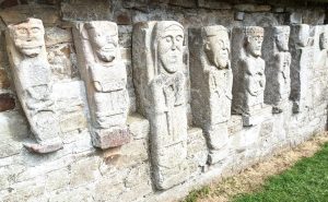
There is little left of the monastery on White Island. The minimal ruins of a 13th century church contain what may be remnants.
Built into the wall are seven carved statues that represent the sole unique feature that set the site apart. The statues are thought to be components of the original monastery that were subsequently left in the rubble after Viking attacks, until retrieved centuries later.
Stepping through the archway within the stone walls, we peered at the figures while Barry did his best to describe what each depicted. They were carved in a style similar to pre-Christian images. In fact, one appears to be a Sheela-na-gig, fertility goddess, similar to the two-thousand-year-old Janus Stone on nearby Boa Island. The others are thought to portray St. Patrick, the biblical David, and Jesus.
More ruins and historical facts were available for Devenish Island, at the far south end of the Lough, where we headed for the final stop. Even from a distance, the island’s landmark round tower stood out marking the spot. Though a more recent addition, only dating from the 12th century, the 80-foot-high stone tower offered a striking visage. All of the visible ruins, including several church structures and a high cross are from this era. Earlier formations are evident in the earthworks, including a prior tower.
Saint Molaise is known to have founded the monastery on Devenish Island in the mid-sixth century. Known as one of the “12 apostles of Ireland,” his reputation spread, and the monastery flourished for many centuries. Molaise was known to have counseled St. Columba to leave Ireland after Columba caused a battle where several thousand soldiers were killed, the result of a dispute over Columba’s copying a manuscript without permission. Columba exiled himself to the Scottish island of Iona, building a successful ministry there.
The Viking raids came about three hundred years after Saint Molaise’s death. The Vikings were merciless, slaughtering and plundering all in their sight. Nevertheless, the monastery was rebuilt and even survived burnings several centuries later. The Maquires of Tully Castle notoriety continued to hold family burials at Devenish into the nineteenth century.
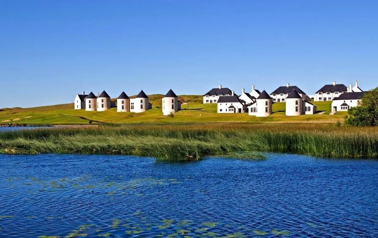
With our tour coming to an end, Barry turned the boat back toward the Manor House Country Hotel near Killadeas. On the way, he pointed out from a distance the sumptuous Lough Erne Resort on the western shore, where several years earlier the then venerable Group of Eight (G8) country leaders met, seeking mutual peaceful goals. Once back at the Manor House, we bid a gracious farewell to our well-versed guide and captain. From the marina, we walked up to the Manor House Dining Room for lunch, where we could look out over the majestic lough, contemplating the rich, colored history that it held.
Lori noticed with curiosity an American flag flying from the hotel roof. She wondered why it was there. As it turns out, the Manor House, itself, had a part in the region’s history. Captain John Irvine acquired the estate where the hotel now stands in 1660, not that long after the rebellion of 1641. The mansion has been rebuilt several times over the centuries. According to the Hotel website, during World War II, the Government requisitioned the mansion for use by the American forces and operated the headquarters there for the seaplane base described earlier in this article.
After lunch, Lori and I made a pilgrimage to Boa Island, completing the day’s sojourn in Irish history. A number of years ago, Lori’s novel, The Thin Place, was set at Caldragh Graveyard on the island, with the Janus Stone playing a key role. Each time we return to Ireland, we visit the Graveyard again. The cleft at the top of the Janus Stone was still filled with rainwater, and coins left for good luck. The Whitethorn tree still thrived nearby, as the legendary “thin place” where the fairy creatures could pass between our world and the “other” world.
With our departure, we placed a coin on the Janus Stone by the others, to commemorate the many lives lost in conflicts over the centuries on this history-rich lough, and to express gratitude for the peace that reins today and hopefully for centuries to come.
Story by Gerald Herter


Leave a Comment