Where in the world would you find the largest concentration of Celtic speakers? The answer is northwest Wales. I was brought up in Liverpool and Chester, on the border between England and Wales. In the 1970s we often went on holiday to North Wales, particularly the Llŷn Peninsula, the slim strip that juts out into the Irish Sea. I remember hearing Welsh for the first time, when a group of girls said something to me in Welsh (probably something rude) and burst out laughing when I didn’t understand. I went back there in 1990 with my sister. We visited a village we remembered; not much seemed to have changed. That’s not so true today, as I recently discovered.
My aim was to walk 150 km of the Wales Coast Path from Pwllheli to Bangor, visiting places where new discoveries are being made about the ancient Celts of the British Isles. However, along the way I observed how an influx of money, mainly from England, is changing parts of this coast and creating tensions with local communities.
Some of those tensions concern the Welsh language.
Welsh is descended from the Brythonic Celtic languages spoken across most of Britain from the Iron Age until the early Middle Ages. It is the only Celtic language not classified as “endangered” by UNESCO, but despite support from the Welsh government, its gradual decline continues. The 2021 Census found just 18 per cent can now speak the dialect. In the County of Gwynedd, which includes Llyn, two-thirds of the population can still speak it.
The first challenge with any coastal walking holiday is booking accommodation at walkable distances. Wild camping is not allowed in most of Britain, and I struggle with the weight of camping gear in any case. I found accommodation, eventually, but some of the gaps were long, and some places, particularly Abersoch and Aberdaron, were expensive. I would find out why when I arrived.
Pwllheli is a working town, less flashy than its neighbour, Abersoch. There are fewer second homes here and you still hear Welsh spoken in its shops and cafes. At the railway station I met my old school friend, Geoff, who still lives in Chester and has a boat at Pwllheli marina. There are two classes of boat owner here. Geoff’s boat is stored on site with a right to launch it once a day. To keep your boat permanently moored, you need serious money, and there is a waiting list.
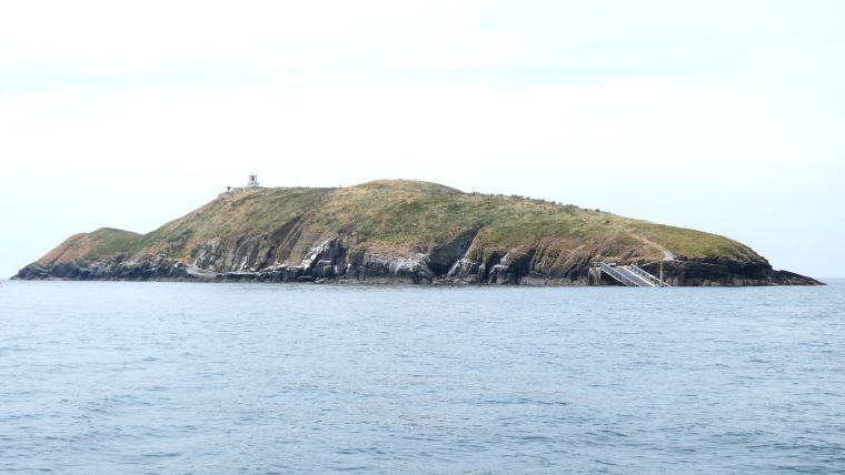
We sailed along the coast, in the direction I was planning to walk, towards Abersoch and St Tudwal’s islands, two small islands surrounded by sea birds. One was bought by the late TV scriptwriter Carla Lane, the other by TV survivalist Bear Grylls, who splits his time between his island and his luxury home in central London. He recently erected Private Property signs – in both English and Welsh – at the insistence of the local authority.
The sun had been shining unbroken for several days and was forecast to continue, which is unusual on this coast.
The first day, 14km from Pwllheli to Abersoch was a gentle introduction. Over the brow of the only hill that day, the long bright sands of The Warren came into view. The beach is public but behind it a trailer park for the super-rich has been gradually expanding. A new extension went on sale recently, with a 17-year lease on a trailer costing up to £800,000 (C$1.7m).
Tractors were towing powerboats, churning up the beach as I arrived in Abersoch. A powerboat yard is the first thing you pass on your way into the town, followed by chic clothing shops and restaurants, which all seemed full. One of them told me I could have a table if I ate up within an hour. One thing I didn’t hear was any Welsh, but I noticed two stickers I would see many times that week saying: Nid Yw Cymru Ar Werth, Wales is not for Sale.
Abersoch has the highest proportion of second homes in Wales: 40 per cent of its housing. The campaign group Cymdeithas yr iath had recently organized a demonstration on King Charles’ coronation day, arguing that second homes are pricing local young people out of the market and “putting the future of Welsh as a community language at stake.”
Responding to these concerns, the Welsh government has recently given local authorities new powers to impose higher taxes. Gwynedd has increased the local tax on second homes to two and a half times the rate paid by permanent residents. Whether that will be enough to reverse those trends remains to be seen.
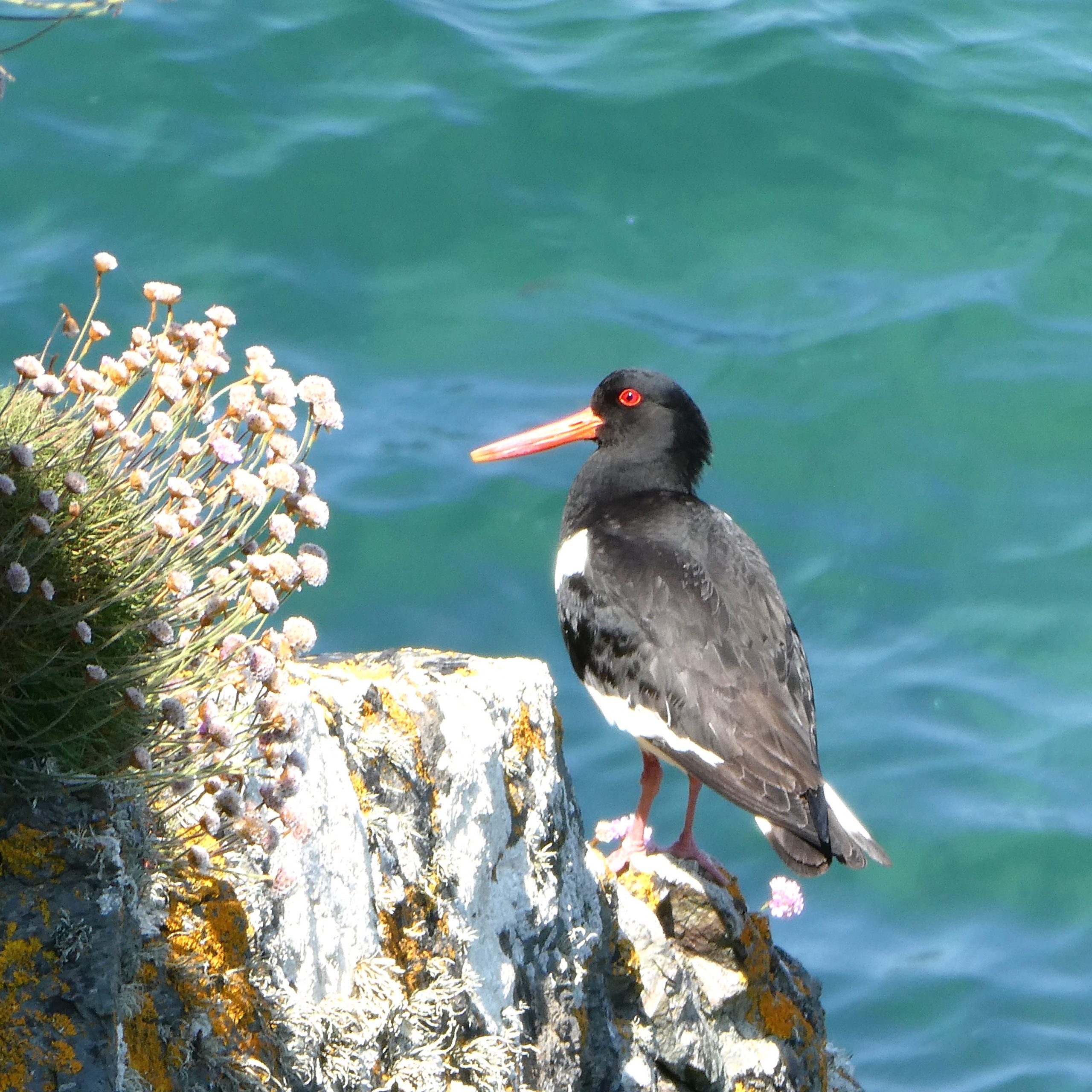
On the farms surrounding Abersoch, caravan parks are spreading. I was relieved to leave all that behind on my second, longer, day to Aberdaron. From this point on, the population thinned out, the scenery became wilder, and I was treated to a cornucopia of wildflowers, birds and other wildlife. I spent too long taking photographs and arrived late on some evenings.
Near Rhiw, the coastal path passes through an area rich with archaeological sites. You can just make out the remains of hut circles and a fort along the path, but the most important finds have come from Meillionydd, on the mountain behind. The excavations have now been covered over but at the end of my walk, I was planning to meet someone who could tell me more about those discoveries.
In Nefyn, I stopped in a churchyard and noticed that the church was now a maritime museum. Inside, I heard two older women speaking Welsh. The museum is run by the local community, and they were both volunteers. Marianne, who had lived there all her life, was helping Julia, who retired there from England, with her Welsh lessons. “Local people appreciate it when you make an effort” she told me.
The Welsh language has held on stronger in those parts of North Wales.
Marianne’s mother came from the South, where the authorities tried harder to eradicate it. Her mother remembered “the Welsh Not” – a board of humiliation designed to hang around the necks of children caught speaking Welsh in school. But she was optimistic about its future: “it will never die out here…we won’t let it.”
Just north of Nefyn, I turned inland towards Llanaelhearn, where I was planning to spend two days visitng the Iron Age hillfort of Tre’r Ceiri. The path cut across the steep face of a mountain, with just enough space to put one foot in front of another, before descending down the side of a cliff, which would have been difficult enough without a full pack. The sun was descending over the trees as I reached Llanaelhearn with a few scrapes and scratches.
The weather forecast was looking uncertain, so I left early to climb Tre’r Ceiri before the hazy sunshine disappeared. The footpath up the mountain started a couple of kilometres outside the village, on a secondary road. At 485 metres, it is the highest hillfort in the region, and the most difficult to reach of any I have visited. The path was rocky, twisting, and steep in places. It is hard to imagine how people could have lived up here, as we think they did for at least some of the time. As I stopped to take a breath, I wondered how often they would descend and climb back up, carrying things they needed to survive. Some recent writings on hillforts have downplayed their military significance and emphasised power and social status, but it is difficult to believe that anyone would choose to live in such a place unless they felt under threat.
The fortified area at the top of the hill is not very large, but there are dozens of hut circles packed into it. Unlike the hut circles that I had passed near Rhiw, the outline of each hut was clear to see. There has been some recent reconstruction, but this is no theme park; it is a collection of ruins, and I was alone there, with a single male cuckoo, calling forlornly for a mate. Some of the huts are attached to each other and some are partitioned, making spaces which seem very small to modern eyes. Who did that, and why?
The fortifications are stronger on two sides; the steep slopes on the other two sides might have seemed protection enough. At its highest point, facing North, stands a large pile of stones: a bronze age burial cairn.
Why did the Iron Age builders choose to build their fortress around it? Were they, as I had read, staking their claim to this, the land of their ancestors?
Despite the haze, I could see the coast and the sea on both sides. The peninsula, which had seemed so challenging to walk around, looked surprisingly small from up here. On one side, I could see the Bay of Caernarfon, where I was heading, on the other, the curve of the coast around Pwllheli, where I had begun.
I left, as I should have arrived, through the main entrance, built into the inner wall and another opening in the outer wall, built later, perhaps in response to an external threat.
The last day of my walk followed the Menai Strait, which runs between the mainland and Anglesey, a bastion of British and druidic resistance to the Roman invaders in the first century AD. Since the 19th century, two bridges have spanned it – one built for road, the other for the railway to Holyhead and the Irish ferries.
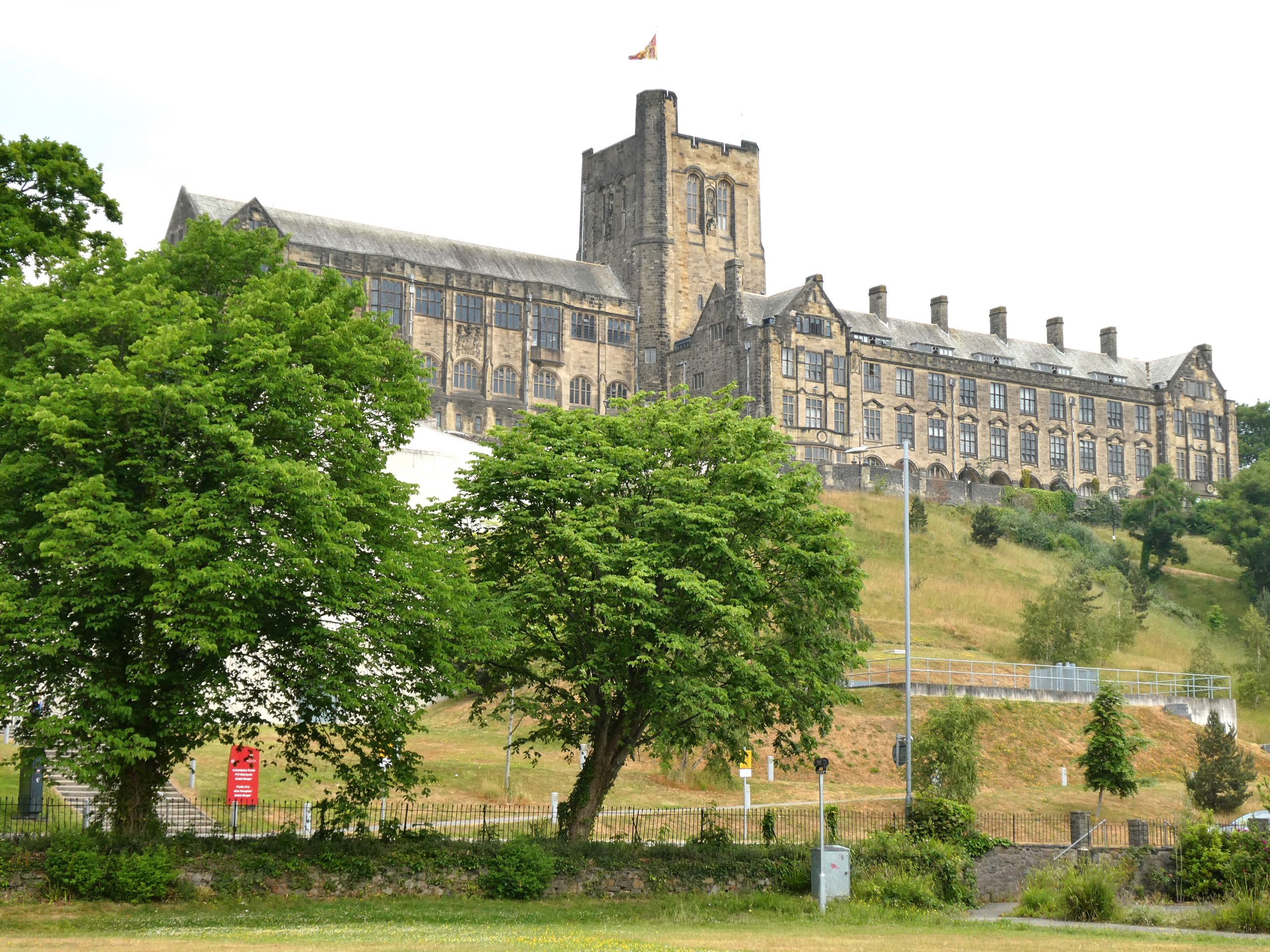
Bangor is an unusual town. With a population of just 18,000, the university, with 10,000 students, dominates the community. Kate Waddington, a Senior Lecturer in archaeology, had asked me to meet her at “the main building”. There was no mistaking which one she meant – it stands on a hilltop overlooking the town centre, designed to make a bold statement when George V inaugurated it in 1911.
Kate has analyzed and written extensively about Tre’r Ceiri. The last excavations there took place in the 1950s, before radio-carbon dating, so many things about it remain uncertain: “It clearly has Iron Age origins. It has clearly been reused in the Romano-British period. Those hut circles were definitely homes, but for how long they were occupied is unknown. However, you can compare it with the Middle Iron Age developed hillforts in Wessex, like Maiden Castle.”
 So why does she believe it was built, and how was it used?
“In times of crisis it would have acted as a refuge, but at other times I believe had a religious significance; it might also have been used for grain storage, but by the Romano-British period its original significance had probably changed.”
The walls were built or rebuilt at that time, suggesting military use.
But why did they partition some of the houses in that period?
“It is strange, this sub-division of houses…the spaces are very small; they might have been temporary structures to be occupied for a certain time, or possibly for storage.”
Kate also participated in several excavations of Meillionydd – a smaller circle, enclosing several round houses. Radio-carbon dating revealed that it was occupied twice, then abandoned. Perhaps the people gravitated towards larger hillforts, like Tre’r Ceiri, feeling a need for greater protection, although there is no evidence of violent conflict.
My last visit was to the Storiel Museum, at the foot of the hill below the university. It did not take long to view its small collection, including a few glass beads, the only finds from Tre’r Ceiri on public display.
On the train home I listened to the recording of my interview with Kate. We talked about Celtic identity and the origins of the Celtic languages. It is easy to imagine those people clinging to the tops of inhospitable mountains as the ancestral speakers of that precious language, but I was left with an impression, after so much work by so many people, that so much remains unknown or yet to be discovered.


Leave a Comment