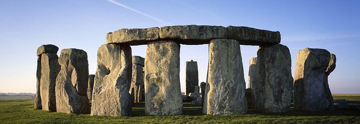
Times had changed in the forty years since my wife, Lori, and I had last viewed Stonehenge firsthand. Back then, a pilgrim could wander in and around the huge stone monoliths, touching and leaning against the cold silent columns, while contemplating the mystery of how they came to be and why.
We were not alone back then, but the number of fellow travelers paled in comparison to the multitudes we found ourselves among on our recent return to this ancient manmade wonder. Rather than complaining, however, we breathed a sigh of relief when we discovered just how close we had come to competing for space with a much greater horde of enthusiasts. Only through some quick, last minute maneuvering were we able to avoid inadvertently arriving at Stonehenge on the day of the summer solstice, when the sun rises directly over the site’s strategically placed “Heel Stone.” While holding profound meaning for the tens of thousands that descend on the monument for that unique experience, for us just the usual crowds on a non-solstice day were challenge enough to contend with.
The routine masses were now kept in check, first by requiring an orderly queue at the relatively new visitor center, followed by a short shuttle bus ride to the actual site. There, a safe distance is maintained several yards away from the multi-ton stones by a rope cordon.
To be fair, the National Trust has done a commendable job in crowd control while providing attractive educational opportunities to learn all about the world heritage site.
A highlight of the visitor center is the 360 degree “Stand in the Stones” experience which gives the sense of being within the stone circle, while taking the viewer through a progressive visual chronology of how the site may have looked down through time, as well as during the winter and summer solstice.

Walking outside the visitor center, near the realistic recreation of a Stonehenge era village, we noticed the first direct tie to Celtic lands. Specimens on display of Stonehenge boulders represented the two rock types that formed the monument. The larger Sarsen stones, composed of sandstone and weighing up to 50 tons, originate from the Marlborough Downs area 20 miles away. However, the smaller, four-ton, bluestones, long considered to have originated in the Preseli Hills in Pembrokeshire, Wales, about 150 miles away, have given rise to a recently renewed controversy over their origin and how they got here, freshly stoking an age-old mystery.
Scientists first theorized the Welsh origin of the bluestones about a hundred years ago.
Since then, further studies have led to general acceptance of that theory. Then in December, 2015, archeologists – completing a multiple year dig – claimed to have found the specific quarry at Craig Rhos-y-felin in Pembrokeshire, pinpointing the source of the bluestones. That claim has been disputed in recent months by another group of scientists, who contend that the quarry-like features at Craig Rhos-y-felin are in fact natural occurrences, with no evidence of man-made intervention. These scientists furthermore renewed another long-contended theory that glacial action brought the bluestones to the Salisbury Plain, and not the colossal efforts of the early people.
A stone harder than granite, bluestones had also given rise to old folk tales that attributed magical healing qualities to them, perhaps justifying their transport from such a long distance. Even this theory is disputed by those who contend that there was no such use found at Welsh sites, and the stones appear to have arrived at Stonehenge too early in time to even be associated with this idea. Another view, however, poses a connection to an ancestral identity that Welsh settlers wanted to bring with them, possibly joining it with the local tradition.
Whether these or other theories prove true, a walk around the path circling the magnificent monument reinforces the notion that the bluestones must have displayed uniquely special qualities to justify their transport from such great a distance so long ago. Viewing them today, the size and presence of the bluestones pale in comparison to the towering sarsen stones, which – at over 20 feet tall – stand more than twice as high as the bluestones. Though originally 80 bluestones formed an inner circle and horseshoe within the more prominent sarsen outer circle, many have been removed or broken over the ages, leaving the remaining specimens to appear in a less orderly pattern.
With heads filled with wonder, and immense respect for the ancient ones who erected Stonehenge, we retreated to nearby Troutbeck Guesthouse in East Chisenbury for a time of quiet reflection. Sitting on the back deck of our room in the rural setting, we sipped on wine while watching a family of swans leisurely float by on the River Avon, a mere twenty feet away. The Avon also winds its way near Stonehenge, a possible means of transport for the bluestones, as well as for the dead being carried from neighboring prehistoric sites.
The next day we walked around another mysterious stone circle complex, this time in Avebury, about 20 miles north of Stonehenge, in the Marlborough Downs region mentioned above. While not as striking as Stonehenge, the Avebury stone circles are surrounded by a circular earthen berm, a thousand yards in circumference, encompassing a large portion of the village of Avebury. An outer stone circle with a thousand-foot diameter encloses two inner circles. In total, there were originally thought to be over one hundred stones in the complex. Quarried nearby, the stones range up to forty tons or more in weight and rise ten to eighteen feet high.
A distinct advantage when walking these circles is the freedom to touch and experience the immense stones up close.
 Other than loosely forming the shape of a circle, the Avebury stones do not appear to display the sophisticated workings or design of Stonehenge.
While strolling the pathway, we encountered two Bobbies on patrol. They were cordial but looked a little out of place. We asked for directions and what they were expecting. “With the coming solstice, the stone circle draws crowds,” one replied. “But with the overcast skies and rain threatening, the enthusiasts appear to be holding off.”
A little further along, we found a dozen solstice devotees gathered near a standing stone, making ready to celebrate the dawn of summer. One curious group member, seeing us reading from a brochure, approached with a somewhat confused look on his face. “Do you know what this is all about?” he queried. Unsure of his intent, we offered him our brochure, which he perused. Thanking us, he returned to the group, still appearing oblivious, but resigned to carry on. A friend had most likely talked him into joining the fun without belaboring the details.
Later, when we had settled into the aptly named Covenstead B & B in nearby Glastonbury, our hostess, an aficionado of all things occult, explained that the group we met at Avebury was most likely enacting a pagan or druid ritual related to the solstice. A little nervous about the occult-themed nature of our accommodation, we opted that night for the Handfasting Honeymoon Suite, hoping that any untoward spirits would prefer less uplifting rooms. Handfasting was an old Celtic tradition where the newly wed couple’s hands were literally bound together, symbolizing their commitment to stay together eternally.
Waking refreshed the next morning, and having experienced no strange occurrences during the night, we were treated to a sumptuous breakfast by our hostess, who proceeded to describe another mystery connecting Stonehenge, Glastonbury and Avebury to the Celtic world. The locations of Glastonbury and Avebury put them directly on the St. Michael Ley Line. Furthermore, Stonehenge, through a geometric, geographic correlation, though not situated physically on that Ley Line, has an indirect connection.
Since I had never previously heard of a “ley line,” Lori gave me a quick lesson. According to Wikipedia ley lines “are apparent alignments of places of significance in the geography or culture of an area, often including man-made structures. They are, in the older sense, ancient, straight trackways in the British landscape, or in the newer sense, spiritual and mystical alignments of land forms.”
The term originated from British archeologist Alfred Watkins, who in 1921 noticed what appeared to be alignments of ancient monuments and geographical features across Britain. He concluded at the time that they were early trackways, as described in his book, The Old Straight Track. Though Watkins drew no spiritual significance to the lines, in recent times such theories have created renewed interest in them.
While there are various theories as to the origins and meaning of ley lines, solid evidence is hard to come by. Some draw a religious purpose, possibly of guides that led ancient ones to sacred places or burial chambers. Others try to connect them with the earth’s magnetic field.
 The St. Michael Ley Line is considered astronomical, since it follows the route the sun takes on the spring festival of St. Michael, the 8th of May each year. The geometric theory comes into play with Stonehenge, as the St. Michael Ley Line through Glastonbury and Avebury forms a perfect right triangle with the location of Stonehenge.
Skeptics contend that with the proliferation of ancient monuments and geographic features in the British Isles and greater Europe, ley lines can be conjured up by drawing lines in just about any direction. Irrespective of the veracity of the ley line theories, Stonehenge has been identified as the hub of several ley lines, even a circular one. The relationship to the St. Michael Ley Line provided the second tie-in to the Celtic world that Lori and I noted. Heading in a southwesterly direction after passing through Avebury and Glastonbury, the line proceeds like an arrow across Cornwall all the way to St. Michael’s Mount at the tip of the protruding peninsula. That was reason enough for us to explore the picturesque Cornish Celtic countryside en route to the line’s namesake origin.
The next day, navigating our way through Cornwall, we decided on the picture-postcard fishing village of Port Isaac as our base of operations. Port Isaac is on the northern coast of Cornwall, about two-thirds of the way from Glastonbury to St. Michael’s Mount. Fans of the British television series, Doc Martin, will recognize the village as Port Wenn, the setting for the medical comedy drama. In fact, our lodging was the old schoolhouse from the show, which has been converted into The Old Schoolhouse Hotel. The dramatic view from our second-floor bedroom windows took in the village and seafront to the left, and Doc Martin’s home and surgery directly across the harbor.
Though we could have sat for hours absorbing the idyllic scene from that historic perch, our immediate objective the following day was St. Michael’s Mount, a couple of hours further south. Nearing the western tip of Cornwall, the road turned toward the southerly coast approaching Mount Bay, near the entrance to the English Channel. To our front, rising majestically 250 feet from the sea, stood the regal form of the St. Michael’s Mount castle and chapel, separated from the mainland by a narrow sand causeway, about a half mile in length.
Legend has it that in the fifth century St. Michael the Archangel first touched down on earth at the peak of the isle. We were surprised that this sacred figure was so closely associated with what for some is a rather fantastical, metaphysical concept of the ley line. St. Michael, after all, is known as a condemner of paganism and heresy, and is a patron saint of Cornwall. Nevertheless, the St. Michael Ley Line got its name from the number of religious structures the line passes through, such as churches bearing St. Michael’s name on Brent Tor in Brentor, Wales, and on Glastonbury Tor.
King Arthur also comes into play along the ley line. He is said to have battled one of the giants that folklore maintains built the isle of St. Michael’s Mount. The purported grave of King Arthur and his queen, Guinevere, can be observed today amidst the Glastonbury Abbey ruins. He even may have used the route of the ley line as a hunting path.
Fortunate to arrive at St. Michael’s Mount during low tide, we gingerly walked the quarter mile cobblestone way from the mainland beach out to the isle. Passing through the village-like setting of shops, gardens, and restaurants, we continued up the path to the castle. Along the way, we spotted a small stone heart set amidst the cobblestones. From another legend of giant killers, the heart is all that remains of a vicious giant, Comoran, who terrorized the island inhabitants during King Arthur’s time. However, the giant killer this time was a lad named Jack. He dug a pit, then covered it over, so that when Comoran passed, he fell in, with just his head sticking out. Jack slayed him, becoming the hero, Jack the giant killer.
The trek to the castle was steep and the stones uneven, but we finally made it. On this gorgeous sunny day, we were captivated by the panoramic view – stretching for miles out to sea and inland, far beyond the bayside resort town of Marazion.

While early history is sketchy at times, in 1080 CE the Earl of Cornwall – a half-brother of William the Conqueror – granted ownership of St. Michael’s Mount to its larger counterpart, the Mont-St-Michel in France. While under French control, the church was completed in the twelfth century. Henry V took back dominion for Britain in 1414. Then in 1659, Colonel John St Aubyn acquired the property, beginning an unbroken tenue of over 350 years, which continues today with the twelfth-generation family of James St Aubyn, who still resides in the castle. Though they turned most of the island over to the National Trust in 1954, the St Aubyn’s retain a 999-year lease to live in the castle and run the visitor business.
As our time delving into Celtic mysteries was drawing to a close, a final coincidental connection came to our attention. In the year 1275 a powerful earthquake simultaneously destroyed the churches on St, Michael’s Mount and Glastonbury Tor.
Digging further, we discovered a 2003 book, Ley Lines and the Earth’s Energies, An Extraordinary Journey Into the Earth’s Natural Energy System, by David Cowan and Chris Arnold, that describes a line of earthquake epicenters that coincide with the St. Michael Ley Line.
Though people at the time may not have grasped the possible scientific explanation for the phenomenon, mystical religious connotations were readily and fearfully envisioned. In 1755 on November 1, All Saints Day, a similar, yet even more destructive earthquake struck. Known as the Great Lisbon earthquake, the magnitude 8.5-9 tremor caused such massive devastation that many feared that the wrath of God had invoked divine judgment.
The diverse scientific, religious and superstitious theories of the Celtic past are certain to perplex visitors and locals alike for a long time to come. Even so, the opportunity to experience these people and places first-hand is sure to enrich the journey. ~ By Gerald Herter


Leave a Comment