Between the ports of Roscoff and Saint-Malo, the northern coast of Brittany twists over 400km of estuaries, inlets, and granite cliffs, including one of the few stretches in the world where the granite turns pink. Its beaches have been shaped by the widest tidal range of continental Europe, and, as I would discover, it has an extraordinary concentration of historical and prehistoric sites.
Brittany is home to the megalith: the huge stone monuments erected by Neolithic peoples and adapted by later generations. In 2019, a Swedish researcher published a study claiming that megalithic culture began here and gradually spread to other parts of Europe. Others have disputed those findings, but two things are certain: it started early here, and thousands of those monuments can still be viewed today.
Apart from the sites I researched beforehand, I was surprised several times to see a standing stone in a private garden, a medieval ruin, a seventeenth-century windmill, or a Gallo-Roman bathhouse hidden behind the bushes on a quiet coastal road.
The Eurovelo 4, a pan-European cycle route, starts in Roscoff and follows this coast, passing several of the prehistoric sites. I followed it with my wife, Sara, detouring from time to time, starting in late September, when the weather cools and the family holidays have come to an end.
We arrived on European Heritage weekend, when buildings and gardens are open to the public. We visited a sixteenth-century house, made of local granite and associated with Mary Queen of Scots, although she never actually stayed there. (She landed in Roscoff in 1548, aged six, and was already betrothed to the French crown prince.) The church, whose tower dominates the old port, is a treasure trove of religious art of the same period, with a few pagan symbols hiding in the corners. A sign invited people to buy and light a candle for the deceased. I lit one for my father, who was raised as a Catholic in Liverpool and died in France last year.
The next day, as we descended toward a headland just off the cycle route, a large flat structure appeared on a hilltop above the houses of the village below. Barnenez is the largest burial cairn in Europe and one of the oldest man-made structures in the world. Like the hillforts of the Iron Age, it commands wide views in all directions, by land and sea – although the sea would have been further away when it was built, 6000 years ago.
Its builders were among the first farmers to arrive in Western Europe. They partly replaced, but also interbred with, the existing hunter-gatherers. Their culture lasted for nearly 2000 years, until something catastrophic happened, which archaeologists have long debated, and on which new evidence has recently emerged.
Barnenez is managed by the Centre des Monuments Nationaux, and there is a small entrance fee. Like many services in rural France, it closes for a long lunch break, so you must time your visit carefully, which I didn’t do, and was unable to visit for a longer time.
There were originally two cairns in the area. It was recognized as an archaeological site in the 19th Century, but that didn’t prevent a local contractor from buying it in 1954 and using its stone for road building. He demolished the smaller cairn and began dismantling the larger one before an outcry in the local media prompted the authorities to intervene. He was convicted and compelled to pay for its partial restitution.
Ironically, the damage he caused has made the site more interesting to view. The stones conceal 11 burial chambers, built in several stages, which are sealed behind iron grills today. On the opposite side, where the stones were removed, reveals how the chambers were constructed. Two thousand years before the Ancient Egyptians “invented” the corbelled arch, the builders of Barnenez were using the same technique: laying flat stones with a gradual overhang to support the roofs of chambers, which have lasted to this day.
Many of Brittany’s megaliths have images or symbols carved on their surfaces.
In Barnenez, most of them are sealed inside the chambers, but one cluster is visible near the entrance to one chamber: shapes like the Latin ℧, possibly horns of an animal or the flight of a bird. They prompted me to wonder: who were these builders and artists, and what became of them?
Part of this coast, from Plestin-les-Greves to Louannec, is known as the Pink Granite Coast. We caught an early glimpse, where the pink granite, coloured by potassium feldspar, begins to mix with the usual grey, at Primel Point, shortly after Barnenez. We would see a lot more over the next few days.
Before we set out, I spoke to Philip Dunn, a British archaeologist of Cornish origin, who runs Time Trails in Brittany, offering guided tours in several parts of the region. One of them takes in four megalithic sites along this coast, which we planned to visit next. The first of them was at Prajou-Menhir, on a quiet road leading towards a small island. We turned into a field, with a grassy bank and a long, narrow stone chamber, an allée couverte or gallery grave. Philip had told me to look for engravings inside it. They were well-hidden in a separate chamber with an entrance just large enough to squeeze through. In the semi-darkness, we could see four lumps within an oval surround, generally interpreted as human breasts.
“That secret chamber has a fascinating story. While the gallery graves were left open, these little chambers were sealed. Inside them, you often find carvings, some of which were painted, and high-status artefacts, which give us a date when the tomb was built,” Philip explained.
For Prajou-Menhir, that date was around 4000 years ago, 2000 years later than Barnenez.
“The gallery graves on this coast are all from that time. They mark a transition from Neolithic culture to the Beaker People. Those earlier populations, who were dark-skinned, dark-haired and blue-eyed, were pretty much wiped out. We think there was a pandemic – there’s been some recent research on that. And then, a few hundred years later, the Beaker People turn up in a landscape full of monuments, and no people. Then they start to honour those earlier monuments.”
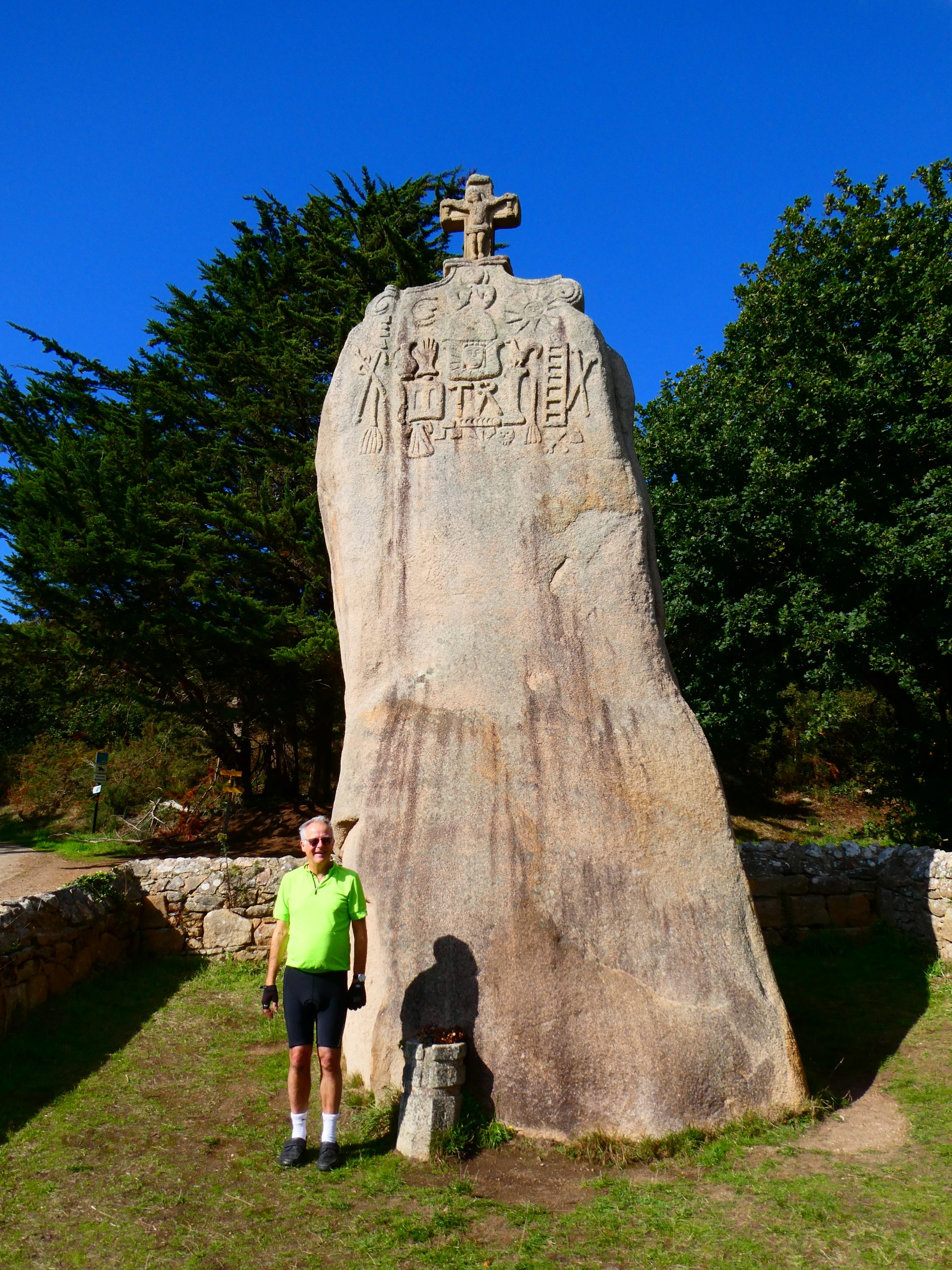
 A few kilometers further east, we reached the menhir of Saint-Uzec, a huge standing stone, topped by a Christian cross, which was added in the Seventeenth Century, when a controversial missionary, Julien Maunoir, was “reconverting” the backsliding Bretons to Christianity. Christian images and Masonic symbols were carved on its upper reaches at the same time. A local woman had told me to look for an indentation on its rear side, about the height of my head. “That was made by the shoulder of the man who put it up”, she said with a smile.
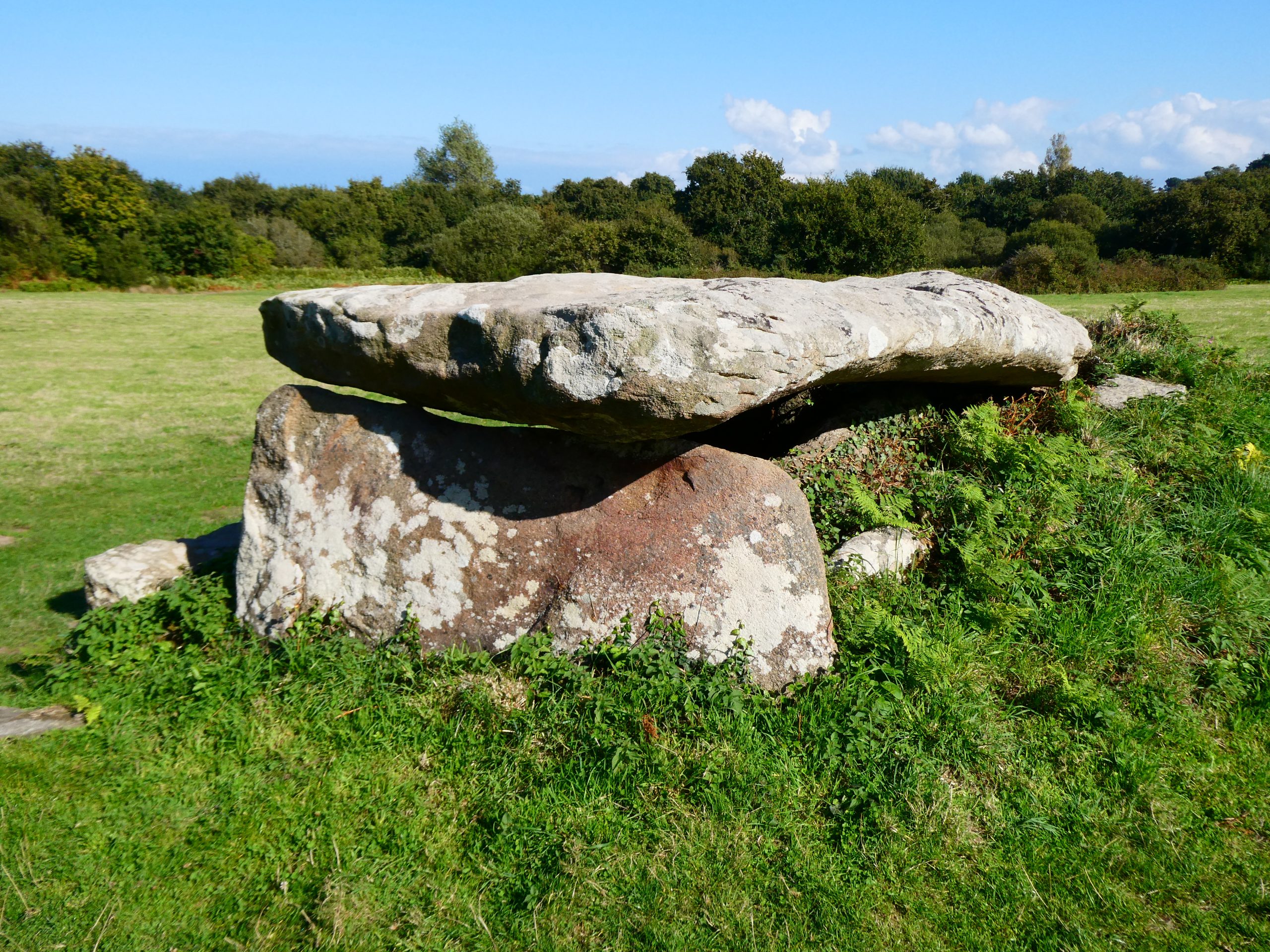
The last of the sites that day, at Kerguntuil, has both a gallery grave and a dolmen, an older, simpler structure topped by one single stone, on opposite sides of the same field. Inside the gallery grave, for those willing to crouch low enough, there is another engraving, like Prajou-Menhir’s but with 12 lumps, six pairs of breasts, possibly belonging to an Earth Goddess, though it’s not exactly obvious. I asked Philip to explain, and he sent me an extract from a book, Statements in Stone, which draws comparisons with other sites, where the form of a woman’s body is clearer.
“I’m not sure I subscribe to the ‘Earth Goddess’ view, but I do think women played an important role in many prehistoric societies that we are yet to understand…”
The most spectacular rock formations on the Pink Granite Coast are in a protected reserve near Perros-Guirec, where we stayed that night. In the 1980s, before the reserve was created, it was under threat from growing visitor numbers. Today, paths define where people can walk, and cycling is banned, so we set out on foot to walk the path to Ploumanac’h and return by bus.
Unlike the sites we had visited so far, the rocks of Ploumanac’h are all natural. The only man-made structures on the seafront are an eighteenth-century customs tower and a lighthouse, rebuilt, using the local stone, after World War II. All around them, wind and water have weathered the rocks into weird and wonderful shapes. One of them, called Dead Man’s Head, resembles a shrivelled skull. Another one is called The Lovers. I waited for the sun to return, to catch them kissing, beside the path that leads to the lighthouse.
The rain held off for several more days, with long stretches of sunshine. Leaves and horse chestnuts were falling from the trees when we arrived in Binic, to find an empty beach, with temperatures still warm enough for one last swim in the sea.
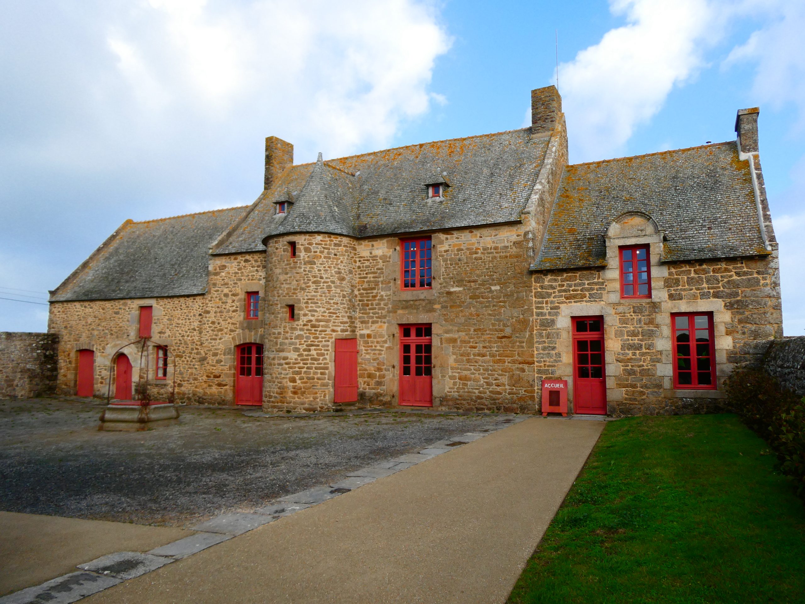
On our last day of cycling, the storms returned. Gales were lashing the beach and the rocks as we arrived in Saint-Malo. In the fields just outside the town, stands the sixteenth-century manor house of Jacques Cartier, which is now a museum and a place of pilgrimage for many Franco-Canadians. Today, Cartier’s name can be found all over Saint-Malo and Quebec, but that wasn’t always so. After he died in 1557, he fell into obscurity until he was reclaimed in the Nineteenth Century as a Franco-Canadian hero, and the man who named the country Canada.
Cartier was a Breton, a Celt. For most of his life, Saint-Malo, where he lived, was part of the independent Duchy of Brittany, although the French language had replaced Breton there by his time. In 1532, when he was 41, a royal marriage brought Brittany under French rule and offered an opportunity to Cartier, who was introduced to King Francis I as an explorer.
 Between 1535 and 1542, he made three voyages, mapping the Saint Lawrence coastline and describing the country in greater detail than any European had done so far. His third voyage was part of an abortive plan to colonize Canada. One critical error changed everything and caused him to fall from royal favour. Believing he had found gold and diamonds, he defied his orders and returned to France, only to discover that his cargo was quartz and iron pyrite or “fool’s gold”. A lump of this shiny but worthless metal lies in a case within the museum today.
Although he never returned to Canada, he remained a prominent local citizen, with a townhouse inside Saint-Malo’s walls and the manor house for the summer. For most of the year (apart from July and August), it is only open at specific times for guided tours, from which there is a lot to learn. Our guide, Magalie, was deeply knowledgeable about the man and his house.
Two Canadians, David and Liliane Stewart, bought it in 1976, refurbished it, and bequeathed it to the municipality after Liliane’s death. As you stand in the courtyard, you can see the three phases of its construction, with a medieval farmhouse on the left and a grander extension built by Cartier in the centre. The decor and furniture, arranged as they would have been in Cartier’s time, seem austere to modern eyes, but would have indicated wealth back then. The old farmhouse was the servants’ quarters; another room was full of maps and a globe, showing how Cartier’s discoveries advanced the geographical knowledge of the time.
Our final visit was back inside the granite walls of the old town. Saint-Malo’s Cathedral was one of many buildings destroyed and rebuilt after World War II. Amongst its ruins, a descendant of Cartier discovered his tomb, which now lies in an alcove beside the nave. A plaque in the floor marks the spot where the bishop blessed him before his first voyage, and a premier of Quebec came to pay his respects in 1891. We sat for a while, contemplating the stained-glass window which commemorates that blessing. For all his failings, Bretons are probably right to celebrate him as part of their long and rich history. ~ Story by Steve Melia


Leave a Comment