It is likely that the Nordic Vikings that first come to mind when the origins of the Icelandic people are considered. The Viking discovered the remote, northerly location later than the British Isles, which were raided and plundered by the adventurous Scandinavians as early as 793 A.D. at Lindisfarne on the north coast of England, and 795 A.D. at the Isle of Iona off Scotland’s coast.
The first Viking settlement in Iceland was established around 874 A.D. at a location that is now the capital, Reykjavik. The first Viking settlement of Ireland’s capital, Dublin, dates to 841 AD. Curiously, DNA analysis reveals that Icelandic women are almost two-thirds Celtic in heritage. The men, however, are only about 20 per cent Celtic.
Those earlier conquests of Ireland and Scotland may hold the answer. Having settled the Celtic lands and founding cities, the Vikings ventured out again. The theory is that Irish women were taken as slaves, helping to populate the virgin land of fire and ice. Some male Celts may have been taken as well. Other theories, though sketchier, surmise that a few Irish monks may have landed in Iceland earlier, in their quest to spread the Christian gospel.
Beyond sharing Celtic DNA, Iceland and Ireland (as well as other Celtic countries) offer an array of both parallels and contrasts. The two islands are relatively similar in size and shape, with Iceland weighing in as the larger at 40,000 square miles compared to Ireland’s 32,000 thousand. Each experiences moist, malleable weather that is tempered by the Gulf Stream. Still, lying some 900 miles to the northwest, Iceland exhibits a clearly colder climate.
My wife, Lori, and I recently experienced Iceland’s subarctic climate while on a cruise. Landing on tiny Grimsey Island at the far north, passengers were excited to hike over to a small signed bridge that demarcated the location of the Arctic Circle. Certificates presented by the ship’s staff commemorated the event.
All of two square miles, Grimsey has only about 60 residents, but thousands of birds dot the landscape, including Arctic Terns, and Puffins (in the summer.) After a short, cold and windy walk along the dramatic barren cliffs, we were content to settle for a hot cup of tea and a traditional specialty, Icelandic waffles covered with chocolate syrup, rhubarb jam and whipped cream.
I asked our host at the Gullsól Guesthouse, one of two on the island, about her business. She tactfully replied “We love it when the ships come in.”
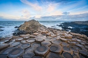
As our ship pulled away from Grimsey, I spotted a coastal feature that conjured up an old Irish legend. Spanning the front of a sheer cliff, orderly basaltic columns rose from the water in a neat row. Visions from earlier sojourns recalled the Giant’s Causeway on the tip of Northern Ireland, and the corresponding Isle of Staffa, off the Scottish Coast. Separated by a mere 82 miles of the North Channel, these two volcanic formations of hexagonal columns form the endpoints for the legend of Irish Finn McCool and the Scottish giant, Benandonnar. Folk lore has it that McCool built the causeway between the two points to dare the big Scot to cross over for a fight. Seeing the larger size of Benandonnar, McCool fled, and he was chased back over the causeway. McCool’s wife covered him in bed, telling the arriving Benandonnar that McCool was her baby. Fearing that the father of such a large baby must be huge, Benandonnar retreated tearing up the causeway as he went. All that is left are the two separated extremities.
While Irish folklore is rich with such stories and fantasy fairy creatures, like leprechauns, Iceland upholds its own mythical traditions centered on the ‘hidden people’ – elves and trolls.
In fact, of the several basaltic formations found in volcanic Iceland, one gives rise to a troll legend of its own. Near Vik on the southern coast of Iceland, three basaltic columns (called ‘stacks’) stand dramatically off the shore of the black sand beach, Reynisfjara. The columns are said to have been trolls trying to lure a ship aground one night. Before they could finish the job, however, the morning sun rose, turning them to stone for all eternity.
A more modern, scientific approach ties the origins of the hexagonal pillars of Iceland and Ireland together. A recent study by a group of volcanologists from the University of Liverpool ascertained that the columns were formed after the molten lava had solidified while still hot. Using a sample basaltic column from the Eyjafjallajökull volcano in southern Iceland, the scientists determined that the lava fractured into the geometric pattern at between 840°C and 890°C. Eyjafjallajökull is the volcano that erupted in 2010, disrupting air travel for several days.
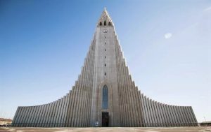
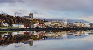
An architectural expression of the symmetric columns rises up as the defining landmark on Reykjavik’s skyline. Hallgrímskirkja, a Lutheran parish church, towers at 240 feet as the tallest building in the capital city. A statue of the most famous Icelander, explorer Leif Erickson, stands in front of the church, a gift from the United States to commemorate the 1000th anniversary of Iceland’s parliament which, as the world’s oldest, first convened in 930 AD.
The parliament met at another site of natural and volcanic beauty, Thingvellir, about 25 miles northeast of Reykjavik. Meaning ‘assembly plains’, Thingvellir was an outdoor setting for the meetings, situated on the crest of the Mid-Atlantic Ridge zone that spanned the geologic meeting place of the Eurasian and North American tectonic plates. Set beside a broad plain, a volcanic fissure formed a natural amphitheater and ravine, ideal for corralling the attendee’s horses, and for giving speeches from a rocky outcrop, the Lögberg, or Law Rock. Nearby Thingvallavatn, the largest lake in Iceland, provided ample fish for the assemblage. Walking through the narrow fissure today gives an eerie feeling of the momentous energy that flowed through the area long ago.
 Thingvellir shares the title of oldest parliament in the world with the Celtic Isle of Man’s Tynwald, whose name has the same root and meaning. While the Icelandic assembly met at Thingvellir until 1798, before its relocation at Reykjavik in 1844, the Manx people claim the title of the oldest continuously meeting parliament for the High Court of Tynwald which still meets in the Manx capital of Douglas.
Fans of Game of Thrones, the fantasy epic television series, may recognize Reynisfjara and Thingvellir as two of several filming locations in Iceland. The wild and remote beauty of the Icelandic landscape harmonized well with the dramatic grandeur of the Game of Thrones storyline. Northern Ireland also offered settings for the ancient tale. On a prior trip, Lori and I almost inadvertently wandered onto a set while roaming in the area of the Giant’s Causeway. Later that day, while sipping tea at nearby Whitepark House, another couple told of accidently driving onto the natural set before being hurriedly escorted away.
The leprechauns of Ireland and the elves of Iceland are thought to have similar origins far back in fairy lore.
They share some characteristics, such as being invisible to humans. The Icelandic elf legend goes back to the beginning of humankind. When God visited Adam and Eve, Eve hid some of her children from God’s sight since she hadn’t finished washing them. Consequently, God decided that these children should remain invisible to humans. Hence, they became known as the “hidden people,” or elves.
A modern-day haven for Icelandic elves is Hafnarfjörður, the harbour and suburb just south of Reykjavik, from whence our ship embarked and returned. Known as the “Town in the Lava,” Hafnarfjörður sits on an ancient lava field. Its unusual volcanic formations supply ideal habitats for elves, who are said to prefer rocky terrain for their dwelling places. Mischievous by nature, elves – even in modern times – have been blamed for broken machinery on construction sites that were considered to be elfin domains.
Another aspect of folklore draws a parallel between two scenic lakes, one more famous than the other. Most of us are familiar with the Loch Ness Monster, purported to ply the depths of the long, deep lake in the Scottish Highlands. But I had never heard of the Lagarfljótsormur. That is, not until passing by the long, narrow lake of that name on a trip out from the port of Seydisfjordur, our ship’s stop on the east coast of Iceland. While tales of “Nessie” go all the way back to St. Columba in the sixth century, the “Lagarfljót Worm,” as this ominous sea creature is known, is relatively recent, having a first mention in the mid-fourteenth century. The monster is large like Nessie and serpentine, but with humps. Legends claim that each will terrorize and kill those unfortunate enough to encounter them on their respective lakes. Reports of sightings continue even into recent times.
While Iceland, Ireland and Scotland all have volcanic origins, Iceland’s location directly on the colliding boundaries of two rift zones gives rise to the more recent active volcanos and other features, such as the geyser basin just east of Reykjavik. Lakes, such as those mentioned above, relate to another common heritage: glacial action.
Iceland, from its northerly locale, is still home to active glaciers. Sadly, the start of our circumnavigation of the island coincided with a memorial tribute to the first death of an Icelandic glacier. The plaque commemorating the momentous event included a Letter to the future:
“Ok is the first Icelandic glacier to lose its status as a glacier. In the next 200 years all our glaciers are expected to follow the same path. The monument is to acknowledge that we know what is happening and what needs to be done. Only you know if we did it.”
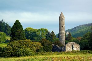
Though Ireland’s glaciers are long gone, another beautiful remnant from an earlier Ice Age is the valley of Glendalough, in County Wicklow, south of Dublin. After cruising around Iceland, our journey took us to Ireland where we drove through this picturesque setting. With a Gaelic name meaning “valley of two lakes,” Glendalough is known for the well-preserved ruins of a monastic settlement established by St. Kevin in the sixth century.
As we walked among the vestiges of the ancient village, the solid granite structures – such as the hundred-foot-high Round Tower and St. Kevin’s Church with its circular belfry – gave testament to the resolve of the monastery community over many centuries. Rising up after destructive Viking raids, Glendalough continued as a beacon of faith until the dissolution of the monasteries by Henry VIII in the sixteenth century. In modern times, Glendalough is a titular diocese of the Roman Catholic Church. Diarmuid Martin, Archbishop of Dublin served as Titular Bishop of Glendalough in the early days of the twenty-first century.
Leaving the valley of Glendalough, a pleasant drive winds through the scenic Wicklow Mountains and up over the pass of Sally Gap. Even driving slowly to absorb the natural essence, we almost missed one of Ireland’s finest waterfalls, Glenmacnass. Cascading 250 feet down the glaciated slopes of the lush valley, the water displayed a yellowish hue from boggish sediment carried along on the rainy afternoon. Nearby, Ireland’s highest waterfall at 400 feet, Powerscourt Waterfall flows over the Wicklow Mountain foothills in a horsetail fan.
Waterfalls are gems of Iceland as well. Gullfoss, in southwest Iceland, exhibits a uniquely intricate pattern as it first flows in curving cascades with water from the Langjökull glacier, then falls dramatically for a hundred feet over a narrow crevice of the Hvítá River canyon.
Our favorite was Goðafoss, just east of Akureyri in the north of Iceland. “It looks like Niagara Falls,” Lori exclaimed, comparing it to the iconic waterfall in North America. Though only falling a quarter the distance that Niagara drops, Goðafoss, meaning “waterfall of the gods” in Icelandic, bears a striking resemblance to its more famous counterpart.
As islands, Iceland and Ireland have ample displays of dramatic sea cliffs.
Ireland’s most celebrated are the Cliffs of Moher, on the western coastline. With over a million and a half annual visitors, the Cliffs are second only to the Guinness Storehouse in Dublin in popularity. My favorite is the more remote Slieve League, further north in County Donegal. At a height of almost 2,000 feet, Slieve League is three times as high as the Cliffs of Moher. Breathtaking as is the view from the top, when I first drove the final quarter mile to get there, before the route was paved, the one lane gravel track dropped off steeply on both sides for a truly heart-stopping experience. Thankfully the road was widened when paved, though I would still hate to have to maneuver around an oncoming vehicle on the narrowest stretch.
Iceland’s cliffs stand out in the form of fjords. Having delighted in the splendor radiated by the fjords of Norway, New Zealand and Alaska on previous adventures, I found the Icelandic version to conjure up memories of the others, such as the sparse population of Alaska’s Inside Passage, the quaint villages of Geiranger Fjord in Norway, and the remoteness of New Zealand’s Milford Sound.
As for population, the whole of Iceland has only 360,000 residents, of which two-thirds are in the Reykjavik metropolitan area. The total is less than 10 per cent of the citizenry of Ireland or Norway. The scant Icelandic population has enabled the preservation of most of the pristine natural characteristics of the countryside. While Ireland has 57 cities exceeding 10,000 inhabitants, Iceland has but five.
One realm where both Iceland and Ireland have sacrificed native conservation is reflected in the lack of trees covering the landscape. Where once woodlands flourished, covering possibly as much as 40 per cent of the land, Iceland now has but 2 per cent forestation while Ireland’s is little more than 10 per cent. The paucity of trees in Ireland often goes unnoticed, overshadowed by the “Forty Shades of Green,” as the Johnny Cash song describes the color that is almost synonymous with the Emerald Isle’s verdant scenery.
In the early days of settlement, lumber was in vast demand for construction of homes and buildings, grazing land for livestock, and for production of charcoal for heating. Today, similar issues have emerged, raising global concerns from the implications of these activities in the Amazon region of South America.
Iceland’s harsh climate, volcanic activity, and resulting erosion make reforestation efforts more difficult than in Ireland. Nevertheless, an ambitious program is underway that has seen several million trees planted in the past couple of years alone. A hike near Egilsstaðir in East Iceland took us through Hallormsstaðaskógur, Iceland’s largest national forest at 286 square miles, and one of over fifty such projects across the country. Started in 1905 to preserve native birch trees, this forest now boasts a diversity of over 85 different types of trees. Along the path we encountered an unusual sculpture of three slender tree trunks carved into totem-like poles, with curved designs and faces as if in tribute to the sacredness of the forest.
The reforestation effort was also evident to us when in port at Akureyri. On the dock by our ship we saw a sign asking for donations for a tree planting campaign. Lori and I now own a tree in Iceland, having made the requested €2 contribution.
As our cruise around Iceland, and subsequent drive across Ireland, drew to a close, we took away new insights from these enchanting islands and their people. With such extensive shared DNA, the least that can be said is that Icelanders are literally Celtic at heart. But as this brief sojourn has shown, the natural and cultural parallels reflect a closer kinship between these hauntingly mystical and mesmerizing lands.
~Story by Gerry Herter


Leave a Comment